Sunday I finally got around to riding the latest extension of the LA River bike path, the new section between Fletcher and the Riverside/Figueroa confluence by Elysian Park.
It was a most pleasant ride indeed, especially when I noted that it ended (for now) just a few minutes’ worth of pedaling from the mighty Flying Pigeon! A useful connection between Pigeonville and the back sides of Echo Park and Silverlake, Atwater, Glendale, Los Feliz, and Griffith Park.
I was pleased to see that this route was treated as a transportation corridor, too: nearly every little street that ends at the riverbank along the new extension has an access to the path–sometimes nothing more than a path and a little gate, sometimes a sweetly-configured pocket parks, with benches and a sculptural gate.
 What it does not have, though, is signs.
That’s right–once you’re on the path, unless you’re intimately familiar with the back yard of the last house on every street, you don’t know precisely where you are.
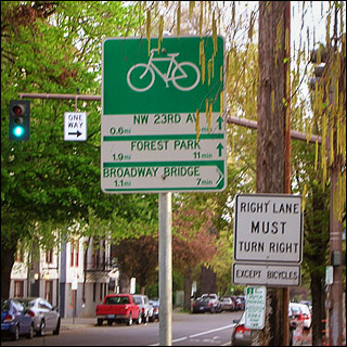
Wayfinding is important, especially on bike-only infrastructure such as this. When you’re riding on the streets, you have little blue and white signs informing you of the name of every little avenue, often supplemented by larger signs over the middles of intersections, and occasionally even larger signboards showing the way to nearby destinations.
Portland, as you see in the photo here, even supplements their normal street signage with bicycle-specific information–that city understands that the best route for cyclists isn’t always the same as the best route for cars.
It’s all the more important when the best route for cyclists takes riders away from the familiar streets they’ve known before and puts them in a separate corridor, however attractive. You need to know where you are if you’re going to get where you’re headed. “Turn left at the house with the blue back door” isn’t quite handy enough for route planning!
Now, yesterday I wrote Michelle Mowery at LADOT Bikeways about this, and she said she would get right to the engineering department about it. And that’s good!
But signage should never have been left off in the first place. If bicycling is to be considered as first-class transport by the average Joe, it can’t receive second-class treatment from our DOT.
I plan on posting a more thorough exploration of this new route soon, with plenty of pictures. Next week, if everything works out! Meanwhile, you can read the LACBC’s report on the extension’s opening here.
One Trackback
[…] to the city’s invisible cyclists. The new L.A. River Bike Path extension is nice, but it could use a little direction; Lisa Newton points out that the historic De Anza Trail runs along its path. LADOT unveils some […]