You could be forgiven for thinking that the title up there refers to the political and bureaucratic clashes the Livable Streets community has been suffering with a number of high-handed city council members and their guerrilla gangs of NIMBY’s, but in this case I’m talking about infrastructure: the bike lanes we’ve got, not the ones we’re struggling for. And the fact is, there are some areas in our slowly-growing clean transportation network that are definitely, as Smart Growth America puts it, “dangerous by design.”
This goes beyond the well-known deficits of door-zone bike lanes, which most people are already aware of. Those present a constant danger that breeds a constant vigilance—at least in those of us who value our own skins. But the conflict zones I’m speaking of sneak up on you, catch you by surprise—and they result from the city’s perceived necessity always to pander to motorists, at almost any cost to the rest of us.
Thye lie in wait for you at far too many intersections—particularly the ones that have right-turn pockets.

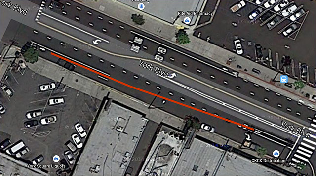
The picture above, ripped off from Google Maps, shows the intersection of York Boulevard and Avenue 64, just southeast of Figueroa. If you happen to be heading to the bridge to make your way to South Pasadena, you find that you have to follow the red line I’ve added to the photo, crossing a lane of car traffic to find the continuation of the bike lane on the left side of the right-turn pocket. There’s no warning; cyclists suddenly find that the bike lane disappears for about eighty feet, to reappear far to the left. Motorists find themselves merging at speed across an invisible bike path that is often suddenly populated by frantic cyclists trying to cut across traffic to avoid a right hook at the corner. There is no indication that previously separated modes are forced to mix here.
This happens far too much in LA. I regularly negotiate similar conflict zones on westbound Venice Boulevard, and there are others on westbound Seventh at Bixel and at Park View. And on eastbound Jefferson, where the bike lane curves along with the main road towards National, I myself have twice narrowly avoided being right-hooked as speeding cars swerved across the bike lane to get to the cutoff to Rodeo Road.
Other cities address this issue by the simple expedient of continuing the bike lane through the conflict zone, and usually painting green rectangles in it to alert both cyclists and drivers to the situation. LA seems reluctant to do so, though I know the idea has been presented to our DOT several times in my hearing.
Santa Monica does it—not only through right-turn pockets, but at any conflict zone, such as busy driveways and most street corners. Long Beach does it. San Francisco does it. But LA, except for some feeble little four-inch stripes on Spring Street, doesn’t do it.
So what’s the problem? The paint can’t be that expensive, can it? Surely our lives are worth a bucket of paint….
One Trackback
[…] Flying Pigeon Takes A Look At L.A.’s Conflict Zones […]